
Stretching across the southwestern corner of Asia, the Arabian Peninsula is one of the most geographically and historically significant landmasses on Earth. It connects two of the world's most ancient civilizations Mesopotamia and the Nile Valley while serving as the birthplace of Islam and the modern global oil economy. Its deserts, coastlines, and mountain ranges have shaped the rise and fall of empires, the movement of peoples, and the flow of global trade for thousands of years. From the ancient incense routes of Yemen to the towering skylines of Dubai, no other peninsula on Earth packs such extraordinary geographic and human diversity into a single landmass. Whether you're studying geography, history, or current events, understanding the Arabian Peninsula definition is an essential starting point.
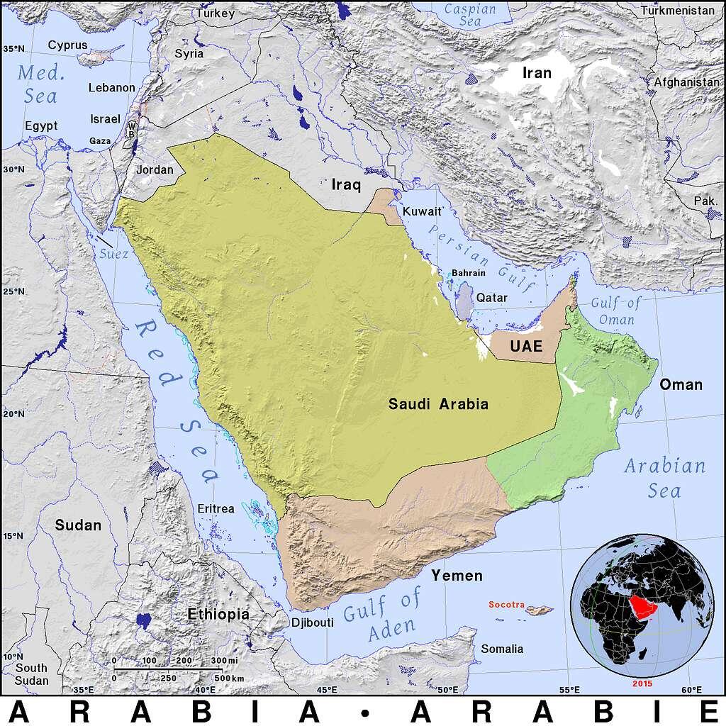
The Arabian Peninsula is the world's largest peninsula, covering approximately 3.2 million square kilometers. It is located in Western Asia, bordered by the Red Sea to the west, the Arabian Sea to the south, and the Persian Gulf to the northeast. The peninsula includes seven countries: Saudi Arabia, Yemen, Oman, the United Arab Emirates, Kuwait, Qatar, and Bahrain.


Defining the Arabian Peninsula
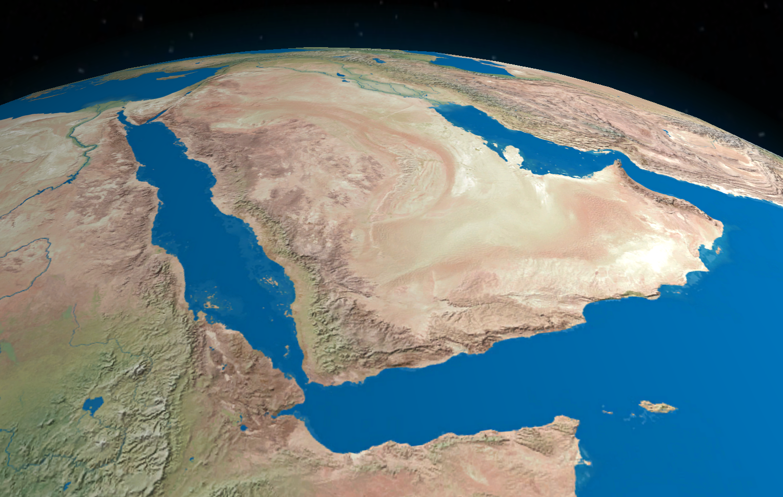
The Arabian Peninsula definition in geographical terms refers to a large peninsula in Southwest Asia, projecting southward from the main Asian continent. It is bounded on three sides by major bodies of water, making it a true peninsula in the classic geographic sense. With a total area of roughly 3.2 million km², it holds the distinction of being the largest peninsula in the world surpassing even the Indian subcontinent when measured strictly by peninsular criteria.
The landmass is predominantly arid, dominated by vast deserts including the Rub' al Khali (Empty Quarter) in the south and the An-Nafud desert in the north, the result of extreme climate conditions that have shaped the landscape for millennia. Despite its harsh interior, coastal regions have historically supported trade, fishing, and human settlement for thousands of years.
Countries of the Arabian Peninsula
The Arabian Peninsula is divided among seven sovereign nations. Saudi Arabia dominates the landmass, accounting for roughly 80% of the peninsula's total area, while the remaining six countries each bring distinct geographies and economies to the region. The remaining countries occupy the coastal fringes and include some of the world's wealthiest nations per capita. Along the eastern coastline, the small but extraordinarily prosperous Gulf states Qatar, Kuwait, Bahrain, and the UAE have leveraged their oil and gas reserves to build modern economies that rival far larger nations. To the south, Yemen and Oman offer a striking contrast, with rugged mountain landscapes, ancient port cities, and histories that stretch back to the earliest days of maritime trade across the Indian Ocean.
| Country | Capital | Area (km²) |
|---|---|---|
| Saudi Arabia | Riyadh | 2,149,690 |
| Yemen | Sana'a | 527,968 |
| Oman | Muscat | 309,500 |
| United Arab Emirates | Abu Dhabi | 83,600 |
| Kuwait | Kuwait City | 17,818 |
| Qatar | Doha | 11,586 |
| Bahrain | Manama | 780 |
Where Is the Arabian Peninsula Located on a Map?
Where is the Arabian Peninsula located on a map? It sits at the crossroads of Africa, Asia, and Europe a geographic sweet spot that has made it a hub of trade and culture for millennia. On any world map, you'll find it in the southwestern corner of Asia, jutting southward between Africa and the Indian subcontinent.
Three major bodies of water define the peninsula's maritime borders:
- Red Sea (west) — A narrow, elongated sea separating the peninsula from northeastern Africa
- Arabian Sea (south) — Part of the Indian Ocean, forming the peninsula's southern boundary
- Persian Gulf (northeast) — A shallow inland sea separating the peninsula from Iran
- Gulf of Oman (east) — Connects the Arabian Sea to the Persian Gulf
- Gulf of Aden (south, near Yemen) — Connects the Arabian Sea to the Red Sea via the Bab-el-Mandeb strait
Which continent is the Arabian Peninsula in? The answer is Asia specifically the subregion known as Western Asia or Southwest Asia (also called the Middle East). While the peninsula sits close to the African continent and shares cultural and historical links with Northeast Africa, it is geologically and geographically part of the Asian tectonic plate. The Arabian Plate, on which the peninsula rests, is slowly moving northward a process that continues to shape the region's seismic activity and landscape. The peninsula is connected to the rest of Asia through its northern borders with Jordan, Iraq, and the Syrian Desert region.
Arabia is a land where sand and sea have shaped civilization as much as any river valley its position between continents made it the world's first great crossroads.
Historical Significance of the Arabian Peninsula
Long before oil made the Arabian Peninsula a household name in global economics, it was a cradle of human civilization and religious transformation. Archaeological evidence suggests continuous human habitation dating back at least 125,000 years, with early populations migrating out of Africa through the peninsula into the wider world.
Ancient Civilizations
The southern part of the peninsula modern-day Yemen and Oman was home to sophisticated ancient cultures. The Kingdom of Saba (Sheba), the Minaean Kingdom, and the Nabataean civilization all flourished here, building complex irrigation systems, trading incense and spices along routes that connected Rome to India. The city of Petra, while located in modern Jordan, was the capital of the Nabataean kingdom whose trade networks extended deep into the Arabian Peninsula.
Birthplace of Islam
No discussion of the Arabian Peninsula definition and significance is complete without acknowledging its central role in the emergence of Islam. In the early 7th century CE, the Prophet Muhammad received the first Quranic revelations in Mecca a city located in the Hejaz region of modern Saudi Arabia. Within decades, Islam spread from this single peninsula across North Africa, Central Asia, and Southern Europe, fundamentally reshaping the medieval world.
The cities of Mecca and Medina, both on the western side of the peninsula, remain the two holiest sites in Islam and draw millions of pilgrims annually during Hajj and Umrah.
Modern Importance of the Arabian Peninsula
In the 20th century, the discovery of vast hydrocarbon reserves transformed the Arabian Peninsula from a relatively isolated region into one of the most strategically important areas on the planet. Today, the peninsula holds an estimated 40% of the world's proven oil reserves, with Saudi Arabia alone sitting atop the world's second-largest reserve base.
Economic Impact
The petroleum wealth of the Arabian Peninsula has funded extraordinary development. Cities like Dubai, Abu Dhabi, Riyadh, and Doha have transformed from modest trading ports or desert towns into global financial and tourism hubs, driven by rapid population growth over the past 60 years. The UAE and Qatar now rank among the highest GDP-per-capita nations in the world.
Beyond oil, the peninsula is increasingly diversifying. Saudi Arabia's Vision 2030 plan, the UAE's push into renewable energy and AI, and Qatar's hosting of the 2022 FIFA World Cup all signal a region actively reshaping its global identity.
Cultural Influence
The Arabian Peninsula has given the world the Arabic language spoken by over 420 million people across 26 countries as well as Islam, one of the world's three major Abrahamic religions. Arabian architecture, poetry, mathematics (the word "algebra" derives from Arabic), and cuisine have influenced civilizations far beyond its borders. The peninsula continues to be a major soft-power hub, with Arabic media networks, global investments, and cultural exports reaching every continent.
🌍 Key Facts: Arabian Peninsula at a Glance
Total Area: ~3.2 million km²
Population: ~90 million
Countries: 7 sovereign nations
Largest Country: Saudi Arabia
Smallest Country: Bahrain
Dominant Religion: Islam
Primary Language: Arabic
Major Resource: Petroleum & gas
Bordering Seas: Red Sea, Arabian Sea, Persian Gulf
Visualizing the Arabian Peninsula
Maps are the clearest way to understand where the Arabian Peninsula is located in the broader context of global geography. On a physical map, you can clearly see how the peninsula forms a distinct wedge shape, bounded on nearly all sides by water. On a political map, the division between the large interior of Saudi Arabia and the smaller, wealthier Gulf states along the eastern and southern coasts becomes immediately apparent.
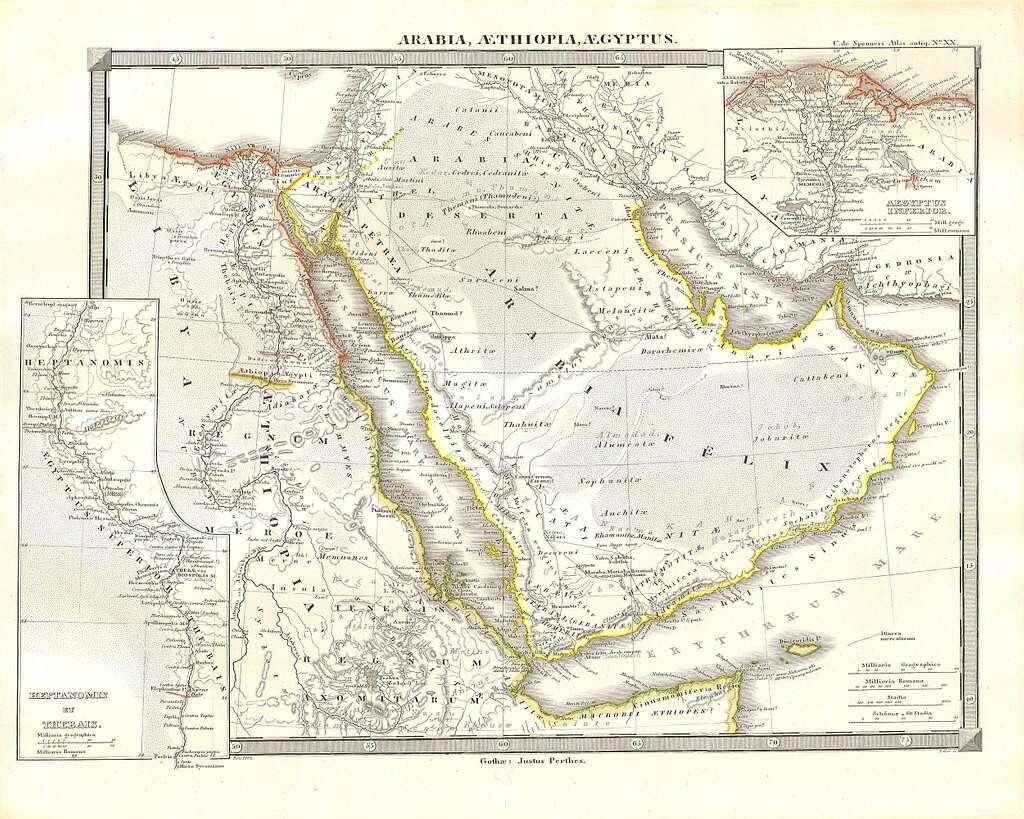
The historical map above titled Arabia, Aethiopia, Aegyptus and published by Justus Perthes offers a fascinating glimpse into how European cartographers understood the Arabian Peninsula in the classical era. Notice how even centuries-old maps accurately capture the peninsula's defining shape: the narrow corridor of the Red Sea cutting along the western edge, and the enclosed waters of the Persian Gulf hugging the northeast. Ancient trade routes, regional kingdoms, and coastal settlements are all marked with remarkable detail. Comparing such historical maps with modern satellite imagery reveals just how little the peninsula's fundamental geography has changed its boundaries remain as distinct and recognizable today as they were for ancient navigators and scholars.
The Arabian Peninsula is far more than a geographic feature. It is a region that has shaped human history across millennia from ancient trade kingdoms and the birth of Islam to the modern oil economy and 21st-century global cities. Understanding the Arabian Peninsula definition, its precise location on the map, and its place within the Asian continent provides essential context for anyone studying world geography, religion, economics, or history. As the region continues to evolve, its influence on global affairs shows no signs of diminishing.
Summarise with AI:
Did you like this article? Leave a rating!

